

GPAC BRIEFING BOOK
Introduction to GPAC
What is a General Plan?
The General Plan serves as a sort of constitution for the city that sets the path forward for development of all kinds. It sets a legal basis for land use decisions and acts as a foundation for communities and planners to put down the vision for the city on a long-term level.
Every city and county in California is required by state law to have a General Plan. Typically, general plans cover a 15-20 year planning horizon. The General Plan discusses the city's goals, policies, and implementation actions regarding future growth, development, and sustainability. Topic areas, called “elements,” that are required to be included in a General Plan include land use, open space, conservation, housing, circulation, noise, and safety. A general plan can also include non-required elements of unique concern to the community.
Petaluma General Plan
The City of Petaluma is currently operating under the City of Petaluma: General Plan 2025, which was written in 2006-2007, adopted in 2008, and last updated in 2012. As the 2025 planning horizon approaches, the City has kicked off the process of updating its General Plan. The General Plan serves as the guiding vision document and provides policies and implementation programs to achieve the City’s goals.
Petaluma has experienced a great deal of change since the adoption of the current General Plan. High priority concerns include availability and affordability of housing, climate change, public health and sustainability. Although the current General Plan horizon year does not end until 2025, the City understands the significant benefits to adopting a schedule that closely ties the update of the General Plan to the update of the Housing Element, which California mandates for completion by the end of 2022.
Updating the General Plan and the Housing Element concurrently provides many benefits including a comprehensive update that accounts for new housing laws that address the availability and affordability of housing in the Petaluma. Taking a proactive approach to update the General Plan will position the City to adapt to significant changes in Housing Element Law and will ensure a comprehensive update that takes into consideration the many challenges surrounding housing in the City as well as other high priority concerns.
Time Commitment
The General Plan Advisory Committee will meet monthly through much of the two-year process, beginning in January 2021 and through January 2023. The process will include phases such as visioning, plan development and adoption. Meetings are generally held on Thursday evenings, but may be scheduled at other times as needed.
The GPAC is a limited-term committee appointed only to provide recommendations regarding the General Plan. At the completion of the General Plan project, the GPAC will be dissolved.
Advisory Role
The GPAC is an advisory committee. This means that the GPAC will not have decision-making authority or recommend decisions to the City Council. However, input from the committee will be forwarded to the consultant team and the City Council for final action. The committee is a key part of the transition from the initial public outreach phase to the development of proposed alternatives for contribution to the draft General Plan.
Committee Member Roles
The GPAC is comprised of community representatives who will serve as advisors, liaisons, and project ambassadors. The committee works collaboratively with the consultant and staff and City staff to make recommendations to the City Council on a variety of issues related to the update of the City's General Plan.
The GPAC will:
Supplement the community input provided at public workshops and provide feedback and guidance throughout the General Plan project.
Provide feedback and direction to the project consultant and City staff, with the goal of developing policies and objectives of the new General Plan that are responsive to community input, conditions, goals, and vision.
Refine the approach taken for each major step in the process, provide feedback through interim steps, review reports, and review policy alternatives to select preferred policies.
Provide guidance at key project milestones.
Communicate information about the General Plan Update to Petaluma community members and encourage all interested parties to participate in the process.
Make a recommendation to the Planning Commission and the City Council on the adoption of the General Plan Update.
The Brown Act
The Brown Act requires government business to be conducted at open, public, noticed meetings. It is based on the state policy that people can be informed on the “people’s business” of governance.
The heart of the Brown Act is a single sentence.
“All meetings of the legislative body of a local agency shall be open and public, and all persons shall be permitted to attend any meeting of the legislative body of a local agency, except as otherwise provided in this chapter.”
This law governs GPAC and requires that these advisory body meetings be held in the public. The Brown Act also means that members of GPAC cannot discuss GPAC-related issues with each other informally (such as at a private barbecue, on an internet message board, or over text messages) without violating the law.
GPAC subcommittees may be able to meet without Brown Act requirements if they are an ad hoc committee consisting of less than a quorum of GPAC members and are dissolved after completing a specific task.
The Brown Act can be complicated for individuals new to public service in California, and it may be worth consulting with the City Attorney’s Office if you have any questions about compliance.
Click here for more information on the Brown Act: https://www.cacities.org/Resources-Documents/Resources-Section/Open-Government/Open-Public-2016.aspx
Role of Subcommittees
The GPAC may choose to create subcommittees of the larger body. These subcommittees could be specific to particular topics (such as climate change or economic development) or particular areas of Petaluma. These subcommittees could meet separately from GPAC as a whole. Care should be taken to determine whether subcommittees should be subject to the Brown Act, described below, and what rules they must follow in order to remain in compliance with the Brown Act.
There is no requirement to form subcommittees, and the GPAC may not feel they are suitable to the mission of the committee as a whole.

The City of Petaluma
History of Petaluma
The City of Petaluma is located in Sonoma County, approximately 40 miles north of San Francisco and 20 miles south of Santa Rosa. The city has a population of approximately 62,000. Petaluma has a long history as a population center and existing buildings date back to 1836. Petaluma has a well-preserved pre-1906 historic Downtown surrounding historic residential neighborhoods on the southwest side of the Petaluma River. US Highway 101 runs northwest/southeast and bifurcates the town. The city is an agricultural center, with a historic focus on egg, poultry and dairy production. The city saw an explosion in population in the late 1960’s due to Highway 101’s construction, leading the city to limit housing development to 500 units/ year (units may be carried over from previous years), and to adopt an Urban Growth Boundary. The East Side, the half of the city located northeast of 101, has a significant proportion of the city’s newer development and is characterized by numerous car-oriented, suburban Planned Unit Developments.

History of Growth Management and Planning in Petaluma
Petaluma was an early leader in public management of population growth. Infrastructure shortages and sprawling subdivisions that were seen to overtax the environmental and aesthetic quality of the community in the 1960s alerted the City to the problems of rapid growth. Further frustrations were felt as the city became divided between the older West Side and the new commuter-oriented East Side. Growth began endangering the local economy by impinging on agricultural and dairy lands, and by drawing retail business away from Downtown to East Side shopping centers. Most importantly, neither the sewer system nor the public school facilities could keep up with the rapid growth. As a result, the City instituted a system of controls to set the pace for new residential construction. Milestones in the City’s growth management history include:
Environmental Design Plan of 1972
The Environmental Design Plan served as a short-range strategic plan, limiting housing construction to a not-to- exceed rate of 500 dwelling units per year for the five-year period 1972–1977. It also established an urban separator (then called greenbelt). Residential Growth Management System (RGMS). The RGMS established the criteria to distribute 500 annual housing unit permits. The review process included a Council appointed citizen committee to review all residential development proposals prior to the Council granting of allocations. Although the allocation process is no longer utilized, the cap of 500 housing units is still monitored.
1961 General Plan
The 1961 General Plan recognized the importance of compact development patterns and cost-effective provision of public services and infrastructure. It provided a framework for development within Downtown, expansion of industrial areas, new parks, residential neighborhoods, commercial areas, schools, and the roadway network.
Urban Limit Line (ULL)
The 1987 General Plan designated a ULL for the period 1987–2005 that identified the outer edge of allowable urban development, encompassing 10,300 gross acres. General Plan population projections for buildout were “between 60,000 and 67,000 persons.” At the time, build-out was expected to be reached by 2008.
Environmental Design Plan of 1978
This reiterated the city’s Urban Growth Boundary (then called Environmental Design Plan boundary), and extended its effective date through 1985. It identified an optimum population of approximately 70,000– 90,000 residents.
Urban Growth Boundary (UGB)
Placed on the ballot by the City Council in 1998, city voters overwhelmingly adopted a fixed urban edge, which for the most part was coterminous with the 1987 ULL. Although the UGB did not affect the growth management numbers, it confined the growth and physical development of the city until 2018. In 2010, the City Council placed a ballot measure before the voters extending the UGB to 2025.
The UGB is nearly identical to the 1987 General Plan Urban Limit Line, although four possible expansion areas were included in the 2010 ballot measure. Voter approval is required to amend the UGB (with minor exceptions) so that rural lands are not prematurely or unnecessarily converted to urban uses. Adoption of the UGB was intended to fulfill the following objectives:
Encourage efficient growth patterns and protect the quality of life by concentrating future development largely within exist- ing developed areas;
Promote uses that foster public health and safety and productive investment for farming enterprises on lands outside Petaluma’s UGB;
Foster and protect Petaluma’s natural setting while encouraging appropriate economic development in accordance with the city’s unique local conditions;
Concentrate growth within a well-defined UGB in order to limit the extent of required City services and restrain increases in their costs;
Allow the City to continue to meet the housing needs for all economic segments of the population, especially lower and moderate income households, by directing the development of housing into areas where services and infrastructure can be provided more cost effectively;
Promote stability in long-term planning for the city by establishing a cornerstone policy within the General Plan designating the geographic limits of long-term urban development and allowing sufficient flexibility within those limits to respond to the city’s changing needs over time.
The 1998 Urban Growth Boundary contains a total of 9,900 gross acres (including streets, the Petaluma River, and other rights-of-way). The four possible UGB expansion areas adopted as part of the UGB Measure include approximately 330 acres, which would be available for annexation given findings that infill acreage is limited and infrastructure capacity is sufficient to serve these outlying areas.
The voter-approved UGB will expire in 2025. The General Plan provides direction to evaluate growth boundary expansion issues at the time of mid-term review in 2015.
Planning Context
In 2020, the City of Petaluma kicked off initial outreach efforts as part of its General Plan and Housing Element Update. The current General Plan was adopted in 2008. The City plans to develop its new General Plan and Housing Element concurrently, with a completion date that adheres to the State’s deadline for Housing Element and environmental review submission: January 2023.
Following the development of the General Plan, the city will update zoning citywide. The City may then develop Specific Plans for the areas surrounding each SMART station. The Urban Growth Boundary will expire in 2025, unless extended by the voters.
City Goals and Priorities (and their relationship to the General Plan)
In April 2019, the City convened a community process to identify focal areas and overarching goals for the City as an organization, as well as immediate priorities and action items. This is the culmination of hundreds of hours of work with input from hundreds of community members, committees and commissions, and City staff.
Our 2019-2021 set of Goals and Priorities covers five goal areas and includes objectives and work plan items that address important initiatives to improve the quality of life for Petalumans. The Goals identified are:
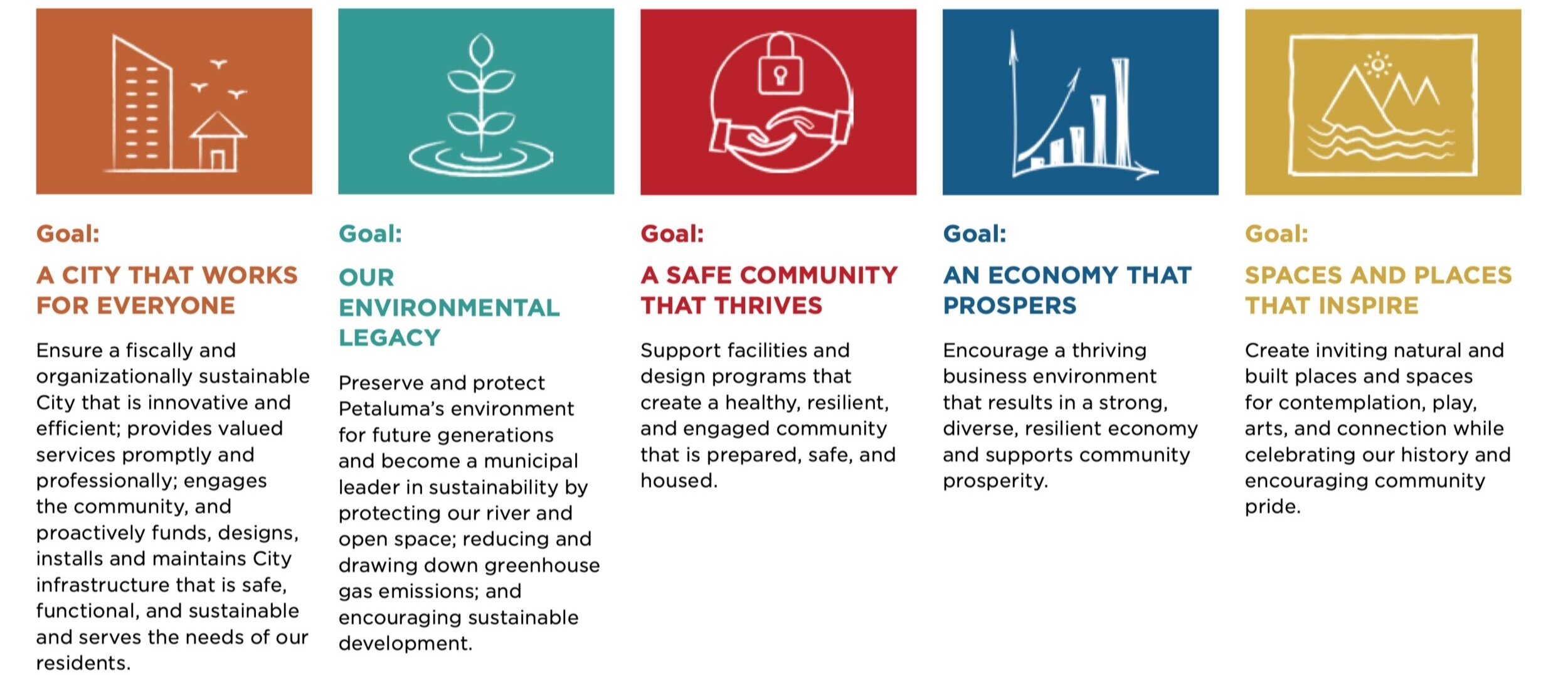
The City and community also identified these focal areas: Affordable Housing Crisis; Infill Housing Development; Climate Emergency; Public Health; Equity; Ecological Sustainability; New FEMA Mapping; City Fiscal Sustainability; and Economic Strength. While these goals and fo- cal areas were identified for the 2019-2021 fiscal years, they are indicative of our emerging vision for our community.
The Goals and Priorities document is available at: https://cityofpetaluma.org/ city-manager-goals-priorities/
Ongoing Planning
Existing Planning plans and projects are accessible on the City’s General Plan project website. These includes:
General Plan
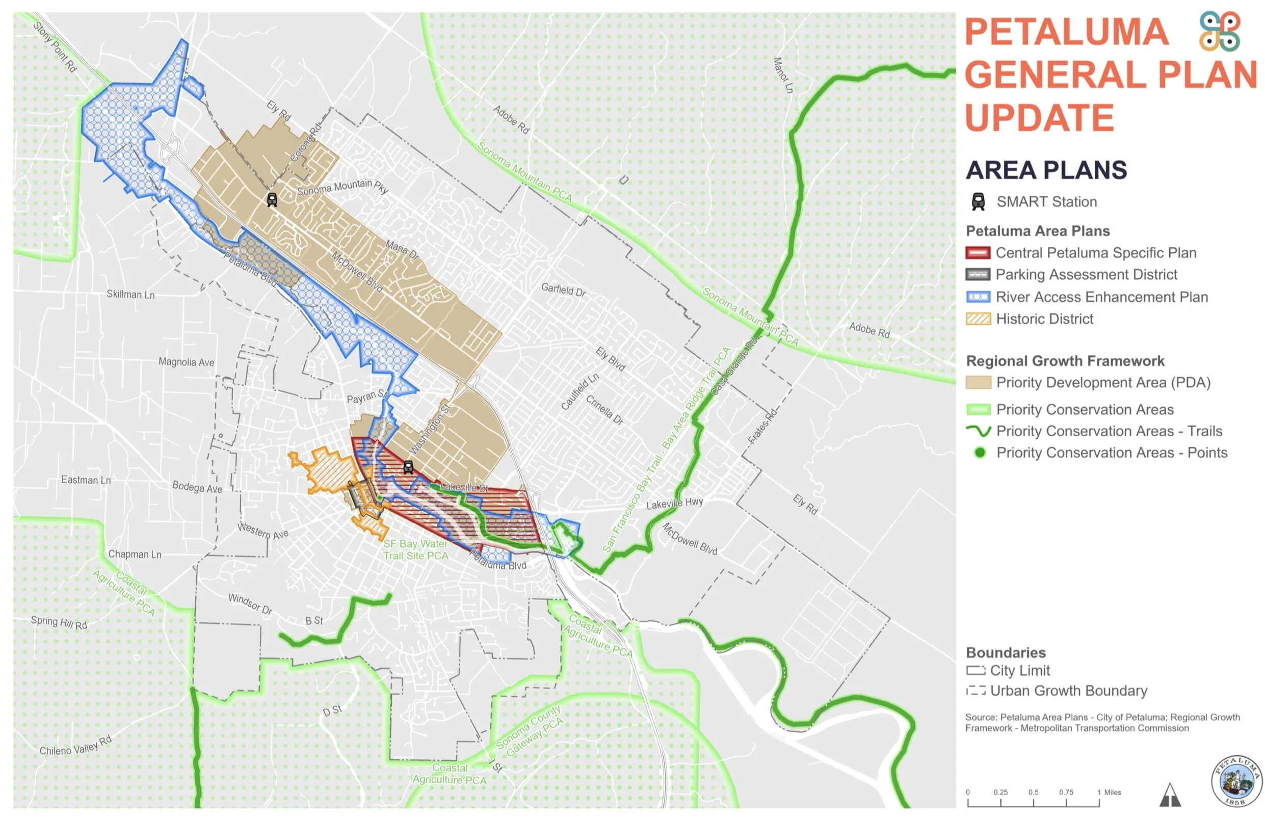
Central Petaluma Specific Plan (CPSP)
Petaluma SMART Rail Station Areas: TOD Master Plan
Implementing Zoning Ordinance (IZO)
Petaluma SMART Rail Station Areas: TOD Master Plan - Appendix A: SmartCode Amendments
A Street Historic District Preservation Guide- lines and Standards
Petaluma Historic Commercial District De- sign Guidelines (complete)
Oakhill-Brewster Historic District Preserva- tion Guidelines and Standards
Bicycle and Pedestrian Plan
River Access and Enhancement Plan
Public Art Master Plan
Vehicle Miles Traveled (VMT) and Environ- mental Review
Several long-range planning efforts have recently been completed or are currently underway and should be considered alongside the preparation of the General Plan.
These planning efforts include:
Local Hazard Mitigation Plan (currently in draft)
Climate Emergency Action Framework
Bicycle/Pedestrian Master Plan
Petaluma Fairgrounds visioning
Local VMT standards
Objective Design Standards for Multifamily development
Permit-ready ADU plans
Water Model Plan and Sewer Modeling
Groundwater Master Plan
Urban Water Management Plan
Flood Plain Model Update and Adoption (HEC- RAS 2D)
Sonoma County Regional Climate Protection Authority Climate Action 2020
Covid-19 Management and Response
Like every municipality in the United States, Petaluma has been deeply affected by the Covid-19 pandemic. The unemployment rate in the Santa Rosa-Petaluma Metropolitan Statistical Area (Santa Rosa MSA) was 11.5 percent in June 2020, down from a high of 14.5 percent in April but drastically higher than the 2.8 percent unemployment rate in February. The Leisure and Hospitality industry has been particularly affected. The estimated 19,000 jobs in the sector is down 28% from June 2019.
To boost patronage of local retailers, the City has developed a parklet and outdoor dining program called “Petaluma Free Range” that allows private businesses to expand dining and retail activities into the public right-of-way in front of the brick and mortar establishment. Another program, Slow Streets Petaluma, uses barriers to discourage drivers on certain streets, allowing pedestrians and cyclists to more safely use the streets and maintain physical distance.
The City has closed City Hall to the public and moved all services to online platforms to minimize in-person interaction and slow the spread of Covid-19. All public meetings are being held virtually on Zoom.
Equity in Petaluma
Promoting social equity is important to the Petaluma community and the City of Petaluma, as is evidenced in the City’s Goals and Priorities. The City plans to prepare an Environmental Justice Element of its General Plan, and notes that there is a significant focus on social equity in the work of the Climate Action Commission.
In response to the social and racial justice protests occurring across the country and particularly spurred by local youth groups in Petaluma, the City’s Public Art Committee sponsored the installation of a Black Lives Matter street mural which was installed on Fairgrounds Drive in front of the Petaluma Regional Library.


Petaluma General Plan Update
Existing General Plan
The City’s current General Plan was adopted in 2008 with targeted updates in 2018. The current General Plan is remarkable and forward-thinking for its time, and continues to be a valuable guide on many issues. However, City and community priorities have evolved, and the City was unable to implement portions of the plan due to impacts of the Great Recession. In light of these factors and based on a community desire to create a new vision for Petaluma, City is initiating this General Plan updated well in advance of the 2025 time horizon of the 2008 general plan.
The City has been developing groundwork for the General Plan to build off of since early 2019. This has included developing Community Goals and Priorities, adopting a Climate Emergency Resolution, initiating creation of a Climate Action Framework, and completing extensive community outreach to inform initial General Plan direction. The results of these efforts are summarized below flowing a brief contextual portrait of the city.
Housing Element
One of the City’s most influential elements is the Housing Element, which is required by State regulations to be updated every eight years. The City’s Housing Element (Chapter 11 of the current General Plan) was adopted in 2015 and must be updated and adopted by December 2022.
As with many communities in California, Petaluma is experiencing a housing crisis. Housing priorities identified through the outreach process include the development of affordable housing, increasing the diversity of housing types including housing affordable to middle-income households, congregate care for the elderly population, and support for the homeless population. Significant challenges facing the development of housing in the City include the difficulty of securing financing by developers, conflicts between ensuring environmental protection and reducing climate change impacts and the need for housing, increased traffic, and identifying suitable community fit.
Like all Bay Area cities, Petaluma must develop its 6th cycle Housing Element by January 2023 and expects to be allocated more than twice the units it saw in the 5th cycle. In 2015, Petaluma’s RHNA was 745 new units, including 302 units for low income. Petaluma housing has grown at a rate of approximately 260 units/year since 2015. As of October 2020, Petaluma has a draft local RHNA allocation of 2,110 units, including 560 Very low income units, 323 low income units, 342 moderate income units, and 885 above moderate income units. This allocation may change.
Many of the sites identified in the current Housing Element have been developed, and there are over 2,000 units in the development pipeline. The City’s current goal is to support the development of denser infill housing that is environmentally responsible, in close proximity to transit, and in- cluding a range in affordability to meet Petaluma workers’ and residents’ essential housing needs. Petaluma has seen significant interest in ADU development.
The City is the recipient of a LEAP grant to support the development of its Housing Element. All work related to the Housing Element must be billed as a separate task for accounting purposes.
Environmental Impact Report
The General Plan efforts include preparing all required items for California Environmental Quality Act (CEQA) compliance. Due to the Plan’s comprehensive nature, an Environmental Impact Report (EIR) will be required. In addition to informing decision-makers and the public of potential adverse environmental impacts, the analysis should also allow environmental considerations to influence the design of the Plan. To this end, and to minimize duplication of work, the CEQA analysis should be prepared in coordination with the development of the Plan. The Plan is envisioned to be self-mitigating to the extent feasible. Mitigation measures should be in a policy format for addition to the final Plan.
The EIR will address the entire General Plan, including sufficient detail and analysis of buildout scenarios. Per the conditions of the City’s LEAP grant funding for the Housing Element, the EIR must provide a project-level review for identified Housing Element sites as much as possible. Environmental work for the Housing Element must be billed as a separate task for accounting purposes.
Required General Plan Elements
There are seven mandatory topical areas, referred to as elements, that must be included in a General Plan including Land Use, Open Space, Conservation, Housing, Circulation, Noise, and Safety.
Additional General Plan Elements
Additional Elements specific to the City of Petaluma are also recommended to be integrated into the General Plan.
EQUITABLE AND RESILIENT COMMUNITIES
Promoting social equity is important to the Petaluma community, as evidenced in the City’s Goals and Priorities. The community has expressed a desire to address structural inequities in policy and work to ensure that the vision and goals it delivers benefit those who have the greatest need and results in increased opportunity and economic vitality for all. Social equity work will begin with the engagement work that will give voice to traditionally underrepresented groups and surface issues often left out of the planning process. There is a significant focus on social equity in the Climate Action Commission’s work.
ENVIRONMENTAL JUSTICE

The State of California’s Office of Planning and Research’s 2017 General Plan Guidelines require that cities with at-risk populations prepare an Environmental Justice Element as part of an updated General Plan. Preliminary analysis indicated that Petaluma will be required to prepare this element. Beyond this requirement, we are dedicated to furthering environmental justice in the city. The City’s intent will be to enhance community health and environmental quality citywide by improving or maintaining air quality, ensuring neighborhood access to healthy foods, promoting equitable distribution of housing types and household income levels, creating a safe pedestrian/bicycle network, and supporting equal access to public amenities such as parks, transit stops, and libraries. The Plan must ensure that no particular group is required to bear a disproportionate burden of impacts from climate change. Air quality and transportation policies must also be included to help reduce air pollutant concentrations in communities located near high volume roadways or other sources of point and non-point pollution. There is a significant focus on environmental justice in the Climate Action Commission’s ongoing work.
ECONOMIC DEVELOPMENT
The approach to the future of the economy becomes even more critical in today’s uncertain era when development funds are limited and creativity in attracting private investment is essential. Businesses and workers are increasingly organizing themselves in cities with the most substantial quality-of-life assets: high-quality public spaces, access to a diverse range of affordable and attractive housing, and a supportive social and cultural environment. The Plan should seize the opportunity to position Petaluma for enduring investment and sustained economic growth.
The General Plan should recognize the changing nationwide retail environment and develop a strategy to adjust to shifting market adjustments and demands for retail, commercial, hospitably, and industrial spaces.
Petaluma values its small businesses and unique, locally owned, enterprises. While commercial and retail facility vacancies exist in Petaluma, the community and City would like to examine ways to maintain and encourage retail and commercial activity and associated jobs. Many stakeholders cited a desire not to over-build retail space and to rather provide flexibility for property owners to respond to the market with flexible uses and land use permissions. A need to support increased residents working from home was also cited as a priority for the General Plan. The City welcomes innovative approaches to promoting and maintaining a balance of mixed-use development, access to services and market responsiveness.
PUBLIC HEALTH
Petaluma is an active community that is proactive about forwarding public health. Several of the committee/commission members engaged during RFP outreach identified public health as a priority for the General Plan. In addition to physical health outcomes, a broad definition of health may also consider well-being, happiness, and kindness, consistent with City Goals and Priorities. Specific comments included needs for healthy food systems, locally sourced food, teen support groups (especially related to identity, mental and emotional health), more community events that are not grounded in the sale of alcohol, more senior health and wellness programs that focus on promoting independence, and providing preventative care that reduces the need for emergency medical services.
Petaluma is committed to being an Age Friendly City. Petaluma has taken initial steps to becoming certified as an Age Friendly City by the World Health Organization (through AARP) and is in the process of conducting a community need assessment. This effort will be coordinated with the General Planning effort. We are interested in having the General Plan include policies to ensure that Petaluma is realizing its commitment to being a community that is welcoming to Petalumans of all ages.
HISTORIC PRESERVATION
Downtown Petaluma has largely retained its his- toric character due to its relative distance from San Francisco and Oakland, survival of the 1906 earthquake, and post-War development focus adjacent to and extending from Highway 101 on the east bank of the Petaluma River. The City and the Historic and Cultural Preservation Committee have identified the continued preservation of local resources, community engagement with Petaluma’s history and historical artifacts, and addressing the potential impacts of sea level rise on Downtown as priorities.
SUSTAINABILITY AND CLIMATE CHANGE

Petaluma has a long-standing and active commitment to sustainability leadership. The City’s Petaluma has a long-standing and active commitment to sustainability leadership. The City’s 2019 Climate Emergency Resolution states the goal of reaching carbon neutrality by 2045 or earlier. Climate change increases the fragility of local and regional ecologies and introduces challenges, such as increased heat, fire risk, sea-level rise, and decreased water supply, which threaten property and quality of life in Petaluma. This component must be closely coordinated with proposed land use, housing, and mobility policies. The General Plan must include climate change adaptation and mitigation policy and strategies in compliance with State law and to increase the resiliency of the City and its most vulnerable communities. The City is open to addressing climate adaptation and resiliency as a stand-alone Climate Action Plan, as an element of the General Plan, or as a set of integrated “in all policies” approaches.
Existing challenges to combating climate change and advancing sustainable practices in the City include existing floodplain-related policies that allow development in the floodplain, limited purview to deny projects based on environmental concerns, and the rapid nature of climate change paired with the need to balance development needs and decreasing our climate impact. Priorities identified in the outreach process include identifying a methodology for projecting sea-level rise, prohibiting development in the floodplain, and incorporating the Climate Action Plan as part of the General Plan. The community and community leaders recommended that the City de- velop a clear and compelling vision of what a climate-neutral Petaluma might look like to develop a positive view of what might be and not simply focus on necessary changes.
The City’s Climate Action Commission is currently in the process of developing a Climate Emergency Action Framework. This will inform General Plan discussions on climate change and associated subjects.
URBAN DESIGN
Residents of Petaluma place a premium on the small-town feel of the City. Maintaining this character while allowing the community to evolve requires a careful approach to urban design. Planning should be focused on the public realm and design guidelines. The City is in the process of developing Objective Design Standards for multi-family development.
INFRASTRUCTURE AND UTILITIES
The City’s Capital Improvements Program (CIP) Division manages major projects in the city. Several projects are listed below in “Existing and Under-Progress Plans.” Community outreach results suggest that broadband internet access is considered an unregulated utility that should be addressed in the General Plan.

PUBLIC ART AND MUSIC
Petaluma has a strong dedication to community arts and cultural offerings. Petaluma has a Public Art Ordinance that secures fees from non-residential development projects to fund the creation and maintenance of public art in the city. The community would like to see additional opportunities to create and enjoy public art, particularly art that is responsive to its unique urban environment.
Climate Change and the General Plan
Petaluma has a long history of innovation. From its earliest days, Petalumans were inventing new tools and expanding commerce. Now that we are facing climate change, the City of Petaluma is leading with sustainability policies and actions that will support the climate. Whether it be new codes for sustainable development, a focus on alternative transportation options, or the installation of electric vehicle chargers, Petaluma will be looking for ways to take action. In late 2019, the City Council adopted a Climate Emergency Resolution and created a Climate Action Commission charged with helping further this effort. The Climate Action Commission along with engagement of the community is currently drafting a Climate Action Framework to articular key priorities for addressing climate change. The City anticipates that the Framework will inform General Plan direction.
Updating the General Plan
The General Plan effort will include comprehensively updating the City’s existing General Plan and adding new relevant topics to put the Plan at the forefront of best planning practice and comply with legislative mandates. The selected consultant will take primary responsibility for the project, collaborating with City staff, General Plan Advisory Committee, City Council, the community and the project team to prepare a comprehensive and updated General Plan. The City would like to update the General Plan using language and graphics that are easily understood by non-technical stakeholders. Most importantly, the Plan should reflect the City’s aspirations for the future and achieve maximum utility with a clear implementation plan. Proposals should provide an outreach plan, to be refined with City staff. Proposals should include a matrix, or similar tool, to illustrate that proposed elements are fully integrated and internally consistent, especially concerning land use, climate, mobility, housing, and open space. Proposals should include a recommendation of the planning period and the relationship between the planning period and Housing Element cycles.
The General Plan development process should include establishing a clear and strongly-supported community vision for the future of Petaluma in early phases
GPAC’s Role
The Council-appointed General Plan Advisory Committee (GPAC) will advise the consultant-led planning effort. The GPAC members are representatives of the residents of Petaluma and include members who live throughout the city as well as people who represent major areas of interest. The GPAC will provide guidance and review of draft planning documents and work with the consultant throughout the planning process.

Resources
Data Overview
Land use
There are multiple projects in Petaluma’s development pipeline. These include entitled projects, entitled projects that are not moving forward due to economics, projects in plan review, and projects that are in initial discus- sion. Two projects are currently in the streamlined SB-35 process, and one is a potential applicant for SB 2612 streamlining. Please refer to the City website for a selection of many of the plans on the pipeline.
Many of the sites identified in the last Housing Element have been developed or are in the development process. The map to the right shows sites developed since 2015 and their relationship to the Housing Element. This map includes ADU development.
Petaluma has seen significant interest in ADU development, as seen in the chart below. The majority of the development has been in the western part of the city. The eastern part of the city is characterized by many Planned Unit Developments (PUDs), where ADUs were often not allowed until the passage of recent state legislation.


Physical Features
The Petaluma River, Highway 101, SMART tracks, Urban Growth Boundary and the hills to the south and west of the city are the primary physical features in Petaluma.
Petaluma River
The City of Petaluma is moving forward with plans to perform maintenance dredging of the Petaluma Marina and if necessary, the Turning Basin in fall of 2020. The Petaluma River has not been fully dredged since 2002 and the Marina since 1998, except for minor dredging performed after the New Year floods emergency in 2006. As a result, the River, especially the Turning Basin, and the Marina have heavily silted up causing severe restrictions to access by commercial and recreational vessels during most of the daily tide cycle. Significant shoaling has caused the cancellation of the annual “Lighted Boat Parade” and other nautical events hosted by the Petaluma Yacht Club in the Turning Basin. Barges from Lind Marine are reportedly operated at less than half full and only during rising tides to avoid running aground. Downtown businesses have remarked on the reduction of business previously enjoyed by visiting yachters.
The Petaluma community is generally hesitant to develop in its floodplain, which encompasses much of the northwestern and southeastern portions of the City. Any new development should take this resistance into consideration.

Transportation and Access
Highway 101 is the primary access route into the city from the north and south, with CA-116 serving as a secondary access route to the east. However, according to a 2020 County study, 69% of trips originating in Petaluma stay within the city. The current General Plan identifies two significant vehicle transportation projects to create additional cross-town connector opportunities, including the southern crossing at Caulfield and the Rainier crossing. The City’s impact fee structure was developed to fund these and other significant infrastructure projects at build out. Additionally, the Lynch Creek trail provides crosstown access for bikes and pedestrians.

Transit
Transit access is provided by Sonoma-Marin Area Rail Transit (SMART) and bus services through Petaluma Transit, Sonoma County Transit, and Golden Gate Transit.
SMART is planned to run between Cloverdale and Larkspur, and is in the process of being developed and expanded. The active track runs from near the Charles M. Schulz-Sonoma County Airport (north terminus) to Larkspur (south terminus, connecting to ferries to San Francisco). The Petaluma Downtown SMART Station has approximately 30-minute headways in either direction from pre-rush hour morning to evening commute. Service has been reduced due to COVID-19 impacts, and now has approximately one-hour headways. There is a planned infill SMART station at Corona Boulevard and North McDowell Avenue: Petaluma North. Funding for construction was authorized by the SMART Board of Directors in June 2020.
Petaluma Transit provides both fixed route (Petaluma Transit) and ADA complementary paratransit services within the Petaluma Urbanized Area (primarily City Limits). The Fiscal Year 2016 fixed route network features a four-bus base network, operating on six different routes, running seven days a week from early morning to late evening. Only one of these routes has 15-minute headways (Route 24 - during rush hour). Petaluma Para-transit operates the same time span as the fixed route, providing ADA (Americans with Disabilities Act) “premium” service, by providing rides to eligible persons to and from any location in the Petaluma Urbanized Area, regardless of the proximity to active fixed route bus service. Sonoma County Transit connects Petaluma to Santa Rosa while Golden Gate Transit connects the city to San Francisco through Marin County and over the Golden Gate Bridge. Neither Sonoma County Transit nor Golden Gate Transit have headways under one hour.

Airport
The Petaluma Municipal Airport is located at 601 Sky Ranch Drive, on the northeast edge of the city. It is bordered by agricultural and parks/open space land on the north and east, and by residential development on the south- west side.
The Airport records about 60,000 take-offs and landings each year, equally split between aircraft based in Petaluma and those based elsewhere.
The airport is a convenient access point for tourist travel into Wine Country and corporate travel to North Bay businesses. It is a hub in FedEX’s freight hauling business and home to Magnon Aircraft’s Petaluma Pilot training center and aircraft maintenance operation.
Infrastructure and Utilities
The City’s Capital Improvements Pro- gram (CIP) Division manages major projects in the city. Additional information about current and planned projects is available here: https://cityofpetaluma.org/ capital-improvements-program/.
Broadband internet access is a concern for some areas of the city.
Vacant Land
Petaluma has limited vacant land within its Urban Growth Boundary. What vacant land exists is generally at the outer stretches, on hilly or otherwise difficult-to-develop parcels. The city projects much of its new devel-opment to be infill development within proximity to transit.
Demographics


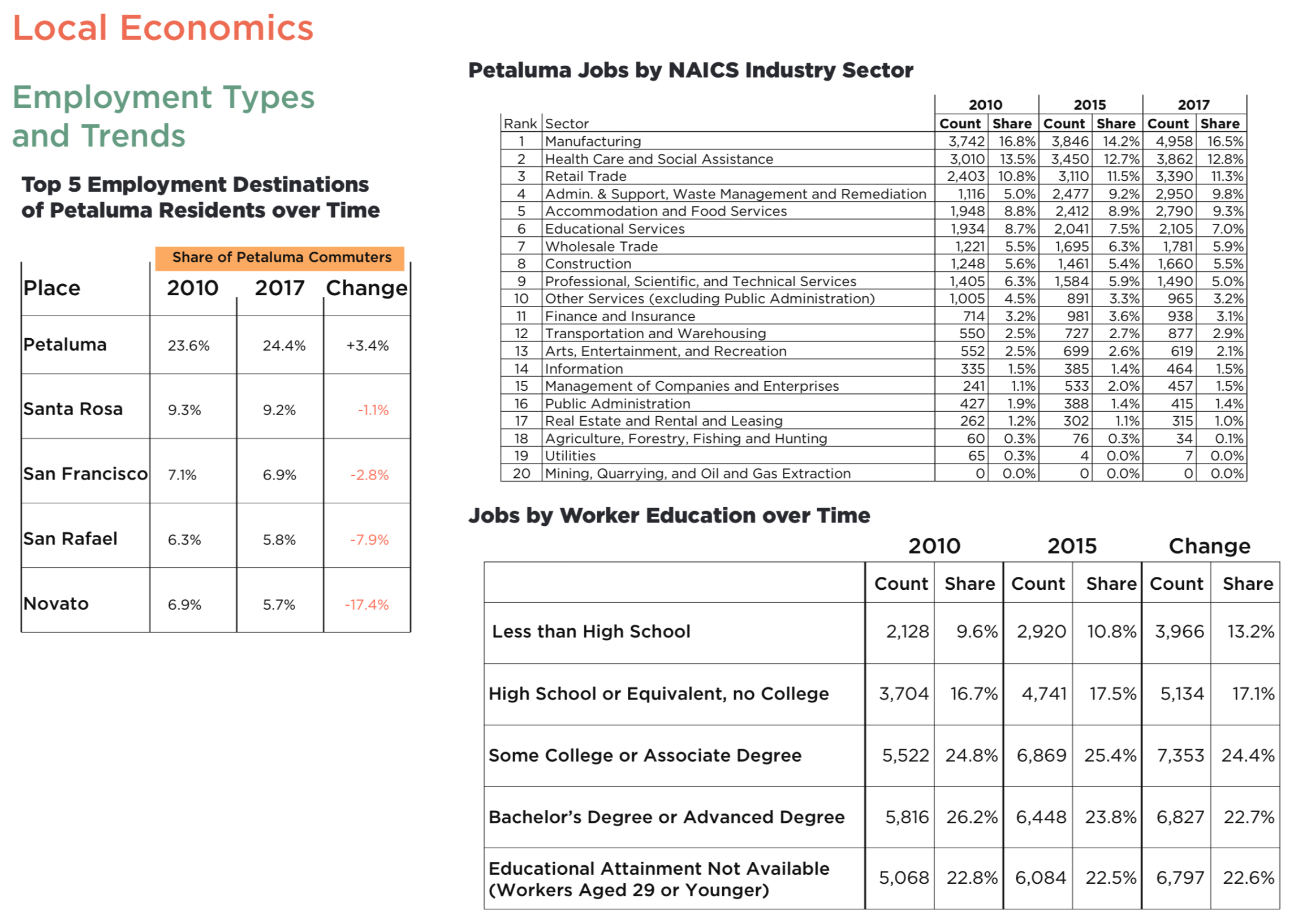
Local Economics

Market Conditions and Trends
The median home value in Petaluma is $735,543. Petaluma home values have gone up 4.4% over the past year and Zillow predicts they will fall -1.6% within the next year. The median list price per square foot in Petaluma is $428, which is lower than the San Francisco-Oakland-Hayward Metro average of $499. The median price of homes currently listed in Petaluma is $695,000 while the median price of homes that sold is $722,800. The median rent price in Petaluma is $2,800, which is lower than the San Francisco-Oakland-Hayward Metro median of $3,300.
Mortgage delinquency is the first step in the foreclosure process. This is when a homeowner fails to make a mortgage payment. The percent of delinquent mortgages in Petaluma is 0.4%, which is lower than the national value of 1.1%. With U.S. home values having fallen by more than 20% nationally from their peak in 2007 until their trough in late 2011, many homeowners are now underwater on their mortgages, meaning they owe more than their home is worth. The percent of Petaluma homeowners underwater on their mortgage is 2.1%, which is lower than San Francisco-Oakland-Hayward Metro at 2.7%.
Commercial Development
Petaluma is located in Sonoma County, a legendary winemaking area (wine, breweries, and specialty agriculture represent $2 billion in sales annually for the County) with a growing technology sector. Office lease rates are a fraction of San Francisco or even Marin County averages ($22.68/sf, compared to $76.40 and $42.00, respectively), while industrial space is slightly more competitive ($12.36/ sf, compared to $24.20 in San Francisco and $15.00 in Marin).
The city of Petaluma itself can be considered as being made up of three large areas: South- east Petaluma, Western Petaluma (Downtown), and Northeast Petaluma.
According to a 2019 real estate forecast, most of the current demand in Petaluma is for in- dustrial, particularly for newly-built class A industrial space. The city’s proximity to Marin and San Francisco make it well-suited to ad- ditional growth in industrial space, particularly if and when labor costs for construction become more moderate.
Government Overview
Sonoma County
Petaluma is located in Sonoma County in Northern California’s bay area.
The Sonoma County General Plan 2020 is a rvision of the previous General Plan which was adopted in 1989. The County Plan establishes a framework for protecting open space and agricultural uses, and limiting new development. The County Plan is generally compatible with the plans of its nine cities, and with plans or policies established by other governmental agencies. Although the County’s plan does not regulate development within Petaluma, it is applicable to lands within the unincorporated portions of the Planning Referral Area. Consultation with Petaluma, however, is required for lands within its Sphere of Influence. In some instances, the policies of the County Plan establish larger “areas of interest” for cities in order to provide for their review and comment on proposed county actions. Sonoma County Area Plans, such as the West Petaluma Dairy Belt Area Plan, should be consulted for areas within Petaluma’s Urban Growth Boundary, beyond the existing City Limits.
Sonoma County has an equity in housing program that the City is a part of, which may provide data on and outreach for our Housing Element efforts related to equity.
Local Government
Petaluma is a charter city with a council-manager form of government. The Petaluma City Council consists of six Council Members and the Mayor. The Council Members are elected at large for a four-year term. Three Council Members are elected at the November
General Municipal election in even-numbered years. This means that at least three Council Members are up for election every two years. The Mayor is directly elected to a four-year term during the General Municipal election in November. Council and Mayoral elections are non-partisan and members are elected as at-large representatives.

Sources of Revenue, Taxation
Please see the City Wide Revenue and Changes chart to the right.
Current Plans Affecting the City
Please refer to the General Plan Website Explore page for information on and links to existing plans.
Relevant Local Policies and Programs
Inclusionary housing policy (15%) ReferenceIZO Section 3.040
Density Bonus Oridnance IZO Chapter 27 (matches state 35% density bonus provisions)
Recently processed two SB 35 applications for affordable housing projects
Smart Code is a form-based code with unlimited density and reduced parking
Transportation Impact Fee has fee reduction provisions if housing is within proximity to transit, services, and does not exceed parking requirements.
All electric reach code and natural gas infrastructure ban
Local Community Engagement
The Petaluma community is highly engaged in community affairs and governance. Below is an non-exhaustive list of relevant community groups.
Commission of the City Council
Formed in November, 2019. Has developed a draft Climate Action Emergency Framework. (https://city- ofpetaluma.org/documents/draft-cli- mate-emergency-action-frame- work/)
SDAT: Group of Petaluma citizens who applied to the AIA for a grant and ULI TAP-like session on sustainable development (grant was awarded, however action was put on hold due to COVID)
Daily Acts: A small but mighty grassroots non-profit. We inspire individuals to reclaim the power of their every daily action to create a regenerative, resil- ient and just world.
Know Before You Grow/Urban Chat: Urban planning discussion group
COTS: Homeless services and shelter
Petaluma People Services Center
Senior Services – Meals-On-Wheels, Adult Day Care, Case Manage-
ment, Nutrition Site-Senior Cafe, TransportationHomeless Prevention, Fair Housing for the City of Petaluma
Employment & Training – Adult and Youth
Counseling – Individual, Couples & Family, Drug & Alcohol Prevention, Gang Prevention
Petaluma Bounty – Healthy Food For All